
José Luis Lerma

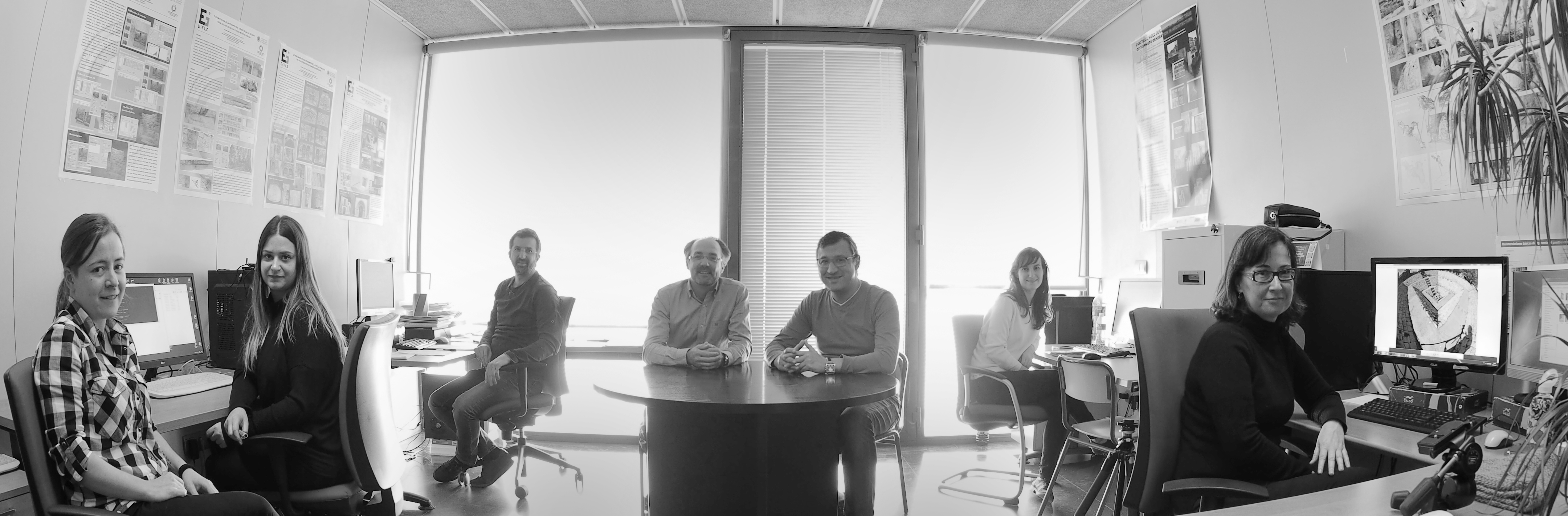
Our team is made up of researchers with degrees in Geodesy, Cartography and/or Geomatics Engineering, Archaeology and Architecture, each one of them specialised in a different area. We work at different levels, academic, institutional and business level, prioritising the R+D+innovation.
José Luis Lerma

Miriam Cabrelles

Gaspar Mora-Navarro
Max Rahrig

Juan José Valero
Omar Christian Quispe Enriquez
Full Professor, Department of Cartographic Engineering, Geodesy and Photogrammetry, Universitat Politècnica de València (UPV). Expert in photogrammetry and laser scanning, and professor of the courses: Cultural Heritage Documentation Techniques at the Higher Technical School of Geodesy, Cartography and Surveying (Valencia); and 3D Printing at the Fine Arts School (Valencia). Coordinator of the PhD Programme in Geomatics Engineering (Interuniversity Programme UPV-UPM).
Technical Engineer in Topography (1992), Engineer in Geodesy and Cartography (1996) and Doctor of Geodesy and Cartography (1999) from the Polytechnic University of Valencia (UPV). His professional experience as a professor in the Department of Cartographic Engineering, Geodesy and Photogrammetry of the UPV dates from 1996. He has published more than 200 contributions (in scientific journals, congresses or books) in subjects related to 3D digitisation, photogrammetry, range-based and multispectral sensors in cultural heritage, engineering, and medicine (citations > 3000, h-index=27, i10-index=72).
Among the many I+D projects in which he has directed or participated outstands: Documentation and exhaustive mapping, within automated methods, of the pathological condition of architectural monuments; Development of an architectural information system for automated modeling, documenting and disseminating multimedia cultural heritage; Integral Study, Documentation and Conservation of Palaeolithic engravings within the Cova de les Maravelles (Gandia); 3DRISKMAPPING: Learning tools for advanced three-dimensional surveying in risk awareness, Leonardo da Vinci project; Development of digital photogrammetry applications; Spanish-Syrian archaeological mission in the Middle Valley of the Euphrates (Deir ez-Zor), Ministry of Culture, CSIC; 3D Reconstruction of the presbytery of the Cathedral of Valencia; Development of a client application to manage aerial image warehouses; Development and implementation of algorithms for architectural photogrammetry; Thermographic and 3D Documentation of Djin Block Number 9 in Petra (Jordan); A window to the past. Levantine rock art in the Valltorta and Gasulla ravines (Castellón); Automatic three-dimensional modelling for heritage documentation; Dense grid multi-image matching generation; Development of functionalities on Isótopo software; Development of photogrammetric software on laser scanning point clouds; Spectrophotometric analysis and camera calibration applied to the study of rock art (HAR2014-59873-R); Responsability for Cultural Heritage through Geomatics; Low-cost photogrammetry to monitor cranial deformation (UPV-FE-2017-B03); Higher education interdisciplinary reform in tourism management and applied geoinformation curricula (2015-3575/001-001); Integration of unmanned aircraft systems (drones) for health logistics: health transport of biological samples; El pasado lejano: aproximación a la conducta y la ocupación del territorio en el Paleolítico valenciano (PROMETEU/2017/060); Non-invasive and low-cost analysis and monitoring of cranial deformation in infants by means of 3D photogrammetry and smartphones (PI18/00881); Development of a web geoportal to facilitate the mapping, dissemination and enhancement of the cultural and natural heritage of Canton Nabón (Azuay, Ecuador)(AD1906); REVIEW – REVealing hIddEn Wall Paintings (H2020-MSCA-IF-2020, No. 101032333); and PhotoMeDAS valorisation as sanitary product for the infants' cranial deformation (INNVA1/2022/53).
Journal's Editor-in-Chief of the Virtual Archaeology Review (VAR). Member of various scientific committees such as CIPA, ICOMOS and SEAV. Reviewer of more than 25 scientific journals. Professor Lerma is currently a member of the Executive Committee of the International Committee for Documentation of Cultural Heritage (CIPA). His research targets automatic photogrammetric processing, data extraction from multispectral imaging, laser scanning technology, and geometric and radiometric calibration of cameras and laser scanners.
Technical Engineer in Topography (2000) and Engineer in Geodesy and Cartography (2010) from the Polytechnic University of Valencia (UPV). In 2001, the Ministry of Education, Culture and Sport granted her a fellowship in "Conservation and Restoration of Cultural Heritage by means of Terrestrial Photogrammetry", developed at the Institute of Spanish Historical Heritage (IPHE). In 2007 and 2008, the UPV awarded her two scholarships in "Image Fusion, Integration of Thermal and Photogrammetry in Heritage Documentation" and "Stereoscopic Vision and Thermography in Architectural Applications", developed in the Department of Cartographic Engineering, Geodesy and Photogrammetry. Since 2007, she has formed part of the GIFLE team, collaborating on various research projects, such as: Developing an architectural information system for automated modeling, Multimedia documentation and dissemination of cultural heritage, Archaeological Syrian-Spanish project in the Valley of the Middle Euphrates (participation in the Campaign III) and Development of the photogrammetric software ORTOFOTOUAV; Thermographic and 3D Documentation of Djin Block Number 9 in Petra (Jordan); A window to the past. Levantine rock art in the Valltorta and Gasulla ravines (Castellón); and Automatic three-dimensional modelling for heritage documentation. She is currently a researcher. Her current fields of research are: Close range photogrammetry: Rectification of images and calibration of cameras; Thermographic analysis in building and restoration: Integration of thermography and photogrammetry, image fusion, and terrestrial laser scanning for the generation of textured 3D models.
Associate Professor at the Department of Cartographic Engineering, Geodesy and Photogrammetry of the Universitat Politècnica de València (UPV). Expertise in computer-aided design, Geographic Information Systems (GIS), geospatial databases and web development. Has been in charge of subjects like Computer-Aided Design, Projects, GIS, Geomatics, Web Develop and Geoportals, Content Managers and Smart Cities, and Spatial Information Distribution.
Surveyor Engineer (1996), Geodesy and Cartography Engineer (2007) and PhD in Ge-odesy and Cartography (2013). Worked from 1996 to 2001 in the private sector, making classical survey jobs. Since 2001, Dr. Mora is an Associate Professor of the Department of Cartographic Engineering, Geodesy and Photogrammetry at the UPV.
Dr. Mora has done projects related to geomatics in different languages like Visual Basic, Lisp, Python, PL/SQL, JavaScript, etc. His research is focused on the study of the cadastral data models, heritage management, and photogrammetry applied to medicine.
Dr Rahrig studied archaeology, preservation science and building archaeology at the University of Bamberg. In 2014, he founded “Format4plus” a company for digital documentation of Cultural Heritage, which he led as managing director until mid-2016. From 2014 to 2020, he was a research associate at the Chair of Preservation Sciences of the KDWT - Centre for Heritage Conservation Studies and Technologies at the University of Bamberg, where he was responsible for high-resolution 3D and non-destructive testing methods. Since 2015, Max Rahrig has been working on research projects to train Sri Lankan archaeologists and conservators in the use of modern documentation methods and assisting in the research and documentation of Sri Lankan Cultural Heritage Sites, such as Sri Dalada Maligawa in Kandy and the ancient wall paintings of Sigiriya. He is a lecturer for 3D documentation of cultural heritage and conservation at the State Academy of Fine Arts in Stuttgart (ABK) and the University of Applied Sciences and Arts in Hildesheim (HAWK). In 2020, Max Rahrig completed his PhD on the topic of “Imaging techniques as non-destructive-testing methods in heritage science”. In 2021 he started the Marie Skłodowska-Curie European PosDoc Fellowship Action “REVIEW – REVealing hIddEn Wall paintings” at the Photogrammetry & Laser Scanning Research Group (GIFLE) of the Department of Cartographic Engineering, Geodesy and Photogrammetry at the UPV.
Graduated in Engineering in Geomatics and Topography (2021), currently studying the Master's Degree in Geomatics Engineering and Geoinformation at the UPV. He carried out the Final Degree Project on identifying and delimiting private property from record and historical graphic bases. His main lines of research are focused on developing applications with Python and Android, as well as the automatic text detection and georeferencing of historical cartography.
Since December 2022 he is a senior laboratory technician (funded by AVI, reference INNVA1/2022/53). He is actively involved in the development and maintenance of PhotoMeDAS as a medical photogrammetric application for image diagnosis.
Geographer Engineer from the Universidad Nacional Mayor de San Marcos, Peru (2015). He developed the thesis "Methodological proposal for the generation of orthophotomaps from aerial images obtained with microdrone-multirotor, study area: beaches district of Barranco, Lima- Perú" to obtain his professional title. Civil Engineer from the Universidad Privada del Norte, Perú (2020). He developed the thesis "Reliability evaluation of the Phantom 4 Pro V2.0 Drone to calculate the condition index of the flexible pavement in Av. Miraflores of the district of Comas, Lima – 2020" to obtain his professional title.
From 2016 to 2018 he developed professional activities in topographical, photogrammetric, geodetic, cartographic, and bathymetric projects located in different regions of Perú. From 2018 to 2021 he developed activities as a georeferencing specialist in the special team in charge of Reconstruction with Changes in the Ministry of Transport and Communications due to the coastal El Niño Phenomenon in Peru. Among the main activities was the evaluation of critical points in national roads using GIS; as well as the evaluation of road and topographic inventory studies for roads and bridges.
In September 2021, he began his Master's Degree in Geomatics Engineering and Geoinformation at the UPV. In February 2023, he joined GIFLE as a research staff. His research delves into the advancement of PhotoMeDAS to turn it into a craniofacial measuring device.

Doctor in Geomatics Engineering at the UPV (2020). Graduated in Geomatics Engineering and Surveying (2014). MSc in Geomatics Engineering and Geoinformation at UPV, and MSc in Geographical Information Management at Cranfield University (2016). In 2014 she obtained a collaboration grant at UPV to work on the project titled “Impact of land cover changes on the hydric resources. Application to Júcar River Basin District”.
She joined GIFLE in 2016 to developed her PhD thesis founded by Generalitat Valenciana and carried out in collaboration with Hospital La Fe. Her PhD thesis was focused on the development of a photogrammetric non-invasive tool for the analysis of cranial deformation in infants. The tool combines Python and Android programming with computer vision and automatic 3D modelling. She actively participated in the conception of PhotoMeDAS, developing photogrammetric tools for medical applications.
Ali Adineh is a B.A. in Conservation and Rehabilitation of Historic Buildings (2006), M.A. in Architecture & Urban Conservation (2009), and PhD student at the Art University of Isfahan in Iran since 2018. He has worked as a Lecturer in Historic Architecture at different universities and institutes of higher education in Iranian cities. Previously, he was a faculty member and the director of the Architecture Department in Ferdows and Meshkat Institutes of higher education in Mashhad, located in Razavi Khorasan province in Iran. He has participated as a designer and supervisor in the conservation and restoration of many Iranian national projects. He has worked as an expert in conservation and restoration for the Ministry of Cultural Heritage, Handicrafts, and Tourism in the cities of Mashhad and Meybod for four years. Most of his studies and activities are in the field of documentation, conservation, restoration and rehabilitation of historic buildings. Mr. Adineh now focuses on HBIM to be used to collect the documents and studies of historic buildings for management and decision-making on cultural heritage interventions.

BSc in Geomatics Engineering in 2012, MSc in Geomatics Engineering (Geodesy) that succeeded with the title of Distinguished Master Student in 2015, and PhD student in Geomatics Engineering at the UPV since 2019. Lecturer in Surveying at the Islamic Azad University (Iran). Previously, he was the director of the surveying group at the Islamic Azad University. He has participated as a surveyor and supervisor in several large-scale construction projects and has worked as a surveying engineer in Ardabil Municipality in Iran. Most of his studies and activities are in the field of surveying and monitoring for displacements and deformations. Mr. Javadi now focuses on panoramic photogrammetry to be used to monitor displacement within geodetic networks. The title of his thesis is "Optimization of geodetic and laser scanner solutions for the monitoring of deformations over long distances".

PhD in Geomatics Engineering (2020), Engineer in Geodesy and Cartography (2014) and Technical Engineer in Topography (2011) by the UPV. In 2014, she holds a scholarship at Eye2021, developing an Android application for blind people guidance by means Bluetooth beacon. In 2015, she gets a scholarship at Research institute La Fe in the research project: “Interactive technology for improving accessibility to interfaces of people with spinal cord injuries.” At the same time, she develops an Android application about database management for a company. In 2016, she joins GIFLE as a researcher where she participates in the project: “Spectrophotometric analysis and camera calibration applied to the study of rock art”. In 2018 she collaborated in the program "New Paradigm / New Tools for Architectural Heritage in Canada" for 4 months, developing augmented reality applications; later at the UPV, photogrammetric applications in medicine. She has extensive knowledge in programming languages and databases such as: C#, Visual Basic, asp.net, Java, Android, Unity (game engine), SQL and database management system MySQL y MS SQL Server. Her main research interests are Augmented Reality application development, creation of interactive virtual scenarios and Virtual Reality. Currently focused on the development of cross-platform mobile applications.

Doctor in Geomatics Engineering (2020) at the UPV. Technical Engineer in Topography (1999); Engineer in Geodesy and Cartography (2013) with Certificate of Academic Excellence from the Ministry of Education, Culture and Sport of the GVA; Master in Geomatics Engineering and Geoinformation (2016) at the UPV. 2nd Francisco Coello International Award (2018) and Jorge Juan and Santacilia Award (2019) for the best Master dissertation. With extensive experience in civil engineering and building, both in leading companies in the private sector and public administration. Professional achievements include teaching as a professor of the subject of Topography in Architecture, in the ESET of the University Cardenal Herrera CEU of Valencia, during the academic years 2004 to 2013. In 2018, he had a 6 months predoctoral research stay at the School of Design of the University of Leeds (UK) within the Colour Research Group along with international references in colourimetry and colour vision. Also, in 2019 he spent a month research stay at Mimar Sinan University in Istanbul, Turkey. The main lines of research are spectral data processing, colourimetry, colour science and vision, colourimetric sensor characterisation through the development of specific tools developed in Python for the rigorous colour registration and image processing and other analysis tools.

Technical Engineer in Topography (2011) from the Polytechnic University of Valencia (UPV). Realization of Final Year Project about architectural heritage 3D modelling and sketching. Engineer in Geodesy and Cartography (2014) from the UPV. Title of the Final Year Project “Multispectral analysis, 3D documentation and interaction in Android devices of rock art”, obtaining an Honours qualification. In 2016, she participated as GIFLE researcher in the project: “Spectrophotometric analysis and camera calibration applied to the study of rock art” working on the improvement of the rock art documentation process by means of multispectral images. In 2018, she collaborated in the training program "New Paradigm / New Tools for Architectural Heritage in Canada" for 6 months, developing augmented reality (AR) applications for dissemination of architectural heritage. Later she collaborated at the UPV developing photogrammetric medical solutions. The main lines of research are the development of new multispectral analysis and scientific image processing, and new cultural heritage dissemination technologies based on virtual reality (VR) and AR.

Dr Alicandro graduated in Environmental and Territorial Engineering at the University of L'Aquila. She obtained a PhD in Civil, Architectural-Construction and Environmental Engineering (DICEAA) in the Geomatics sector at the same university. Since 2012 she collaborates with the Geomatics laboratory of the DICEAA. He carries out research and teaching activities in the field of geomatics and in particular in innovative techniques of surveying. The main research topics concern the use of UAV, photogrammetry, remote sensing and GNSS techniques applied to the study, management and monitoring of the territory, infrastructures, and structures. Since August 2019 she is a Research Fellow at DICEAA of the University of L'Aquila on a PON AIM (Attraction and International Mobility) with the project “Scan to E/HBIM Procedures for Knowledge, Management, Design and Development of Historical Built Heritage”. During this period, she spent two stages abroad at the Department of Cartographic Engineering, Geodesy and Photogrammetry of the UPV (Spain) between 2020-22. At present, she is a lecturer in “Geomatics”, “Digital Cartography and GIS”, “Topography and Cartography” at the University of L’Aquila.

PhD in Statistics and Optimization at the Universitat de València (UV) in 2020. MSc degree in Biostatistics of the Department of Statistics and Operations Research at the UV. Also graduated in Geodetic and Cartographic Engineering at the UPV. The main fields of research are Bayesian statistics and computational probabilistic modeling with emphasis on sampling computation methods and flexible non-parametric and structured models such as Gaussian processes and hierarchical models. The applied research has been mainly focused on analyzing environmental and socio-ecological data, as well as photogrammetric and remote sensing image data, to support management and decision making on a wide variety of applications. Computer vision and image processing are also areas of his knowledge and interest.
Degree in Geography from the University of Santiago de Compostela (2001). Specialized in urban and regional planning. He was the first on his promotion 1997-2001/02. Title of Final Year Project: "Elaboration of a local development plan for the municipiality of Santa Comba (A Coruña)”. Master in Planification and Local Development by the University of A Coruña (2001). Leading Engineer in Geodesy and Cartography (2006) from the Polytechnic University of Valencia, double major: (a) cartography-GIS and (b) geodetic-geophysics. Title of the Final Year Project: "LIDAR technology (Light detection and ranging) and its application for the generation of digital urban models”. Master in Real Estate Valuation by the Center for the Economic Engineering (INECO) of the Polytechnic University of Valencia (2005). Industrial Engineer, specialized in mechanics, also from the Polytechnic University of Valencia (waiting for the presentation of the Final Year Project). Certificate of Advanced Studies at the University of Santiago de Compostela (2006). Title supervised research: "Analysis for the elaboration of a GIS for the management of services in the Department of Innovation and Industry of the Galician government. Cartographic improvement and possible cartographic and photogrammetric applications within General Direction of Tourism-Turgalicia". PhD in Civil Engineering at the School of Civil Engineering of Roads, Canals and Ports (thesis stage) within the Department of Mathematical Methods and Representation of the University of A Coruña, in collaboration with the Institute of Traffic and Road Safety (INTRAS) in the University of Valencia.
Has received among other honours the “Manuel Colmeiro Award” (2007) by the Presidence of the Galician government for the better work of Public Administrations of Galicia. It has also been finalist in the “Jordi Viñas i Foch Award” (2007) organized by the Cartography Institute of Catalonia (ICC), “Padre Tosca Award” (2006) organized by the Valencian Cartographic Institute (ICV). ESRI quality mention award for his Degree Final Project (IV Edition, 2013) and second award of Ideas Foundation STARUPV in the modality of Degree Final Projects 2K13 (2013).
In recent years has combined professional activity with the researcher activity. Has participated in work practices in both private company (Tecnoma-Typsa) and the Public Administration (General Direction of Tourism of the Galician government and Valencian Cartographic Institute). Since 2010 works as technician in the LiDAR section of the ICV.
As researcher he has published in various topics related to his broad spectrum training: public administrations, local studies, strategic plans, fire and forest management, urban planning, industrial maintenance, LiDAR, GIS, CMMS, cartography, demography, road safety, tourism and tourism management. He has published in such journals as the Galician Journal of Economics of School of Economics of University of Santiago de Compostela, the Journal of Urbanism at the Faculty of Architecture and Urbanism of the University of Chile... as well as organizations such as the United Nations of Public Administrations (UNAP), the Central American Institute of Public Administration (ICAP) and the Galician Studies and Development Institute (IDEGA).
He has participated in several conferences related to LiDAR such as the Engineering Institute of Spain (IIES) and other related to tourism management and touristic cartography in the Centre for Tourism Studies and Research (CETUR) and the Tourism Research Institute of Galicia (IET).
Undergraduated in Cartographic Engineering from The Military Institute of Engineering (1984). Master's in Computer Science /Computer-Assisted Cartography from The Military Institute of Engineering (1988). Doctor of Philosophy (Ph.D.) in Mapping and GIS from The Ohio State University (1997)..
He is currently an Associate Professor in the Faculty of Engineering of The Rio de Janeiro State University (UERJ). He has experience in Geosciences, focusing on digital photogrammetry, photogrammetric mapping, remote sensing and computer-assisted cartography.
Technical coordinator of the project "The E-FOTO project: A Free Digital Educational Photogrammetric Workstation", aimed to the development of a GNU/GPL photogrammetric workstation for educational purposes. The E-FOTO project won the Bronze Medal in the "6th CATCON (Computer-Assisted Technology Contest)", held in the "XXII International Congress of Photogrammetry and Remote Sensing ", in Melbourne (Australia), in 2012.
Full Professor at the Universidad de Castilla-La Mancha (UCLC), area of Cartographic Engineering, Geodesy and Photogrammetry, Department of Geologic Engineering and Mining, Higher Technical School of Agricultural Engineering in Albacete.Doctor in Geodesy and Cartography (1999) from the UPV, Engineer in Geodesy and Cartography (1996) from the Polytechnic University of Valencia (UPV) -First National Extraordinary Award in the degree-, and Technical Engineer in Surveying (1991) from the Polytechnic University of Madrid -First National Extraordinary Award in the degree.
Lecturer in three universities: UPV (1994-2000), Universidad de Salamanca (2000-2006) and UCLM (since 2006). Lecturing at three different levels: first, second and third, and covering a wide range of subjects in geomatic engineering such as astronomy, geodesy, mathematical cartography, photogrammetry, geodetic networks, surveying methods, monitoring, object-based software development oriented to geomatics, etc.He is author of a large number of teaching publications related with his lectures, namely Geodesy, Mathematical Cartography, Surveying and Photogrammetry.
He has participated in a large number of Research and Development projects financed by public and enterprises, dealing with software development in geomatic applications. The following development might be enhanced: C++ software for planning and execution planning of aerial flights with matrix digital cameras adapted not only for PNOA but for other projects related with the National Geographic Institute (IGN), other public administrations and flight companies. He has also developed a C++ Software for flight planning with UAVs. He has also participated in the development of the C++ software in Linux PW, Photogrammetry Workbench, second prize award at CATCON, ISPRS 2012, http://www.isprs.org/catcon/catcon6.aspx. He is the author of different software tools in C++ and Matlab for surveying and geodetic applications, highlighting GeoTop library (Matlab and Octave) used for teaching in different subjects. He was the head of the extension JCRS in gvSIG to make use of a variety of reference and coordinate systems from different countries. He has developed C++ software requested by the IGN related to the transition from ED50 to ETRS89 for the file transformation of dgn format and for the creation of a new cartographic grid.
Nowadays he is involved namely in software development in photogrammetry, computer vision, positioning systems and direct georeferencing. Member at the Instituto de Desarrollo Regional, Universidad de Castilla-La Mancha (IDR-UCLM) within the GIS and Remote Sensing Group where he is the head of Geodesy, Cartography and Photogrammetry. He is representing the UCLM in the Comission of Cartographic Coordination of the Junta de Comunidades de Castilla-La Mancha.

Graduated in Geoinformation and Geomatics Engineering at the Universitat Politècnica de Catalunya (UPC) in 2019. Master's Degree in Geomatics and Geoinformation Engineering at the Universitat Politècnica de València (UPV). He is currently pursuing a PhD in Geomatics Engineering at the UPV with the doctoral thesis "Geolocation of land registries through genealogical and geodemographic studies at municipal scale".
Researcher at the Institute for Regional Development (IDR) of the University of Castilla-La Mancha (UCLM), teaching assistant in geomatics at the School of Agricultural Engineering and Forestry and Biotechnology (ETSIAMB) of Albacete and UCLM. His main lines of research are framed in sociological geomatics in the field of genealogy and geodemography; land management and administration; heritage and tourism; and geomarketing and geopolitics. He has been a student representative of Geomatics in Catalonia (2015-2019) and the Valencian Community (2019-2021). He is currently the representative of the Doctoral School and the University Senate of the UPV.
Ana Elena Seguí Gil

Chiara Altomare

Cristina Portalés Ricart
David García San Miguel

Fernando Guillem Ortiz

Francesca Duca

Miriam Sanmartín Casero

Santiago Fabado Salvador

Santiago Navarro Tarín

Serena Artese

Sergio Galcerá Ustero